That matters more than usual here, because the single most repeated claim about this location — that it is on Sarjapur Road — is not what the filings describe. For location reading, Urban Oasis by Modern Spaaces keeps the context local: commute anchors, school access, hospital reach, retail convenience, and last-mile movement decide whether the address works.
The address on the Modern Spaaces Sarjapur Road filings
The Standard Terms of Reference granted on 2 July 2026 by SEAC Karnataka, under proposal number SIA/KA/INFRA2/582779/2026 and state file number SEIAA 220 CON 2026, records the site as follows.
| Field | As recorded in the filing |
|---|---|
| Survey numbers | Sy. Nos. 18 and 19 |
| Village | Chikkadunnasandra Village (village code 613220) |
| Hobli | Sarjapura Hobli |
| Taluk | Anekal Taluk |
| District | Bengaluru Urban |
| Postcode | 562125 |
| Planning authority | BMRDA |
| Land extent | 3.0755 hectares, being 7.60 acres |
| Promoter | Modern Spaace Realty LLP |
| Registered office of the promoter | No. 73/2, Chambenahalli Village, Dommasandra Post, Sarjapura Main Road, Bengaluru |
One point of housekeeping before the location itself. The filing records 826 residential units and a club house over 2 basement floors, ground and 45 upper floors. It does not state how many towers those are distributed across, so this site publishes no tower count, and neither should anything else describing this project.
The approving authority is BMRDA. That is consistent with the marketing material and needs no correction — but it is worth understanding what it implies. This is not a BBMP address. Approvals, layout sanction and the associated compliance sit with the Bangalore Metropolitan Region Development Authority rather than the city corporation, and the civic services a buyer would take for granted inside the corporation limits are not automatically present here. What is and is not available at the parcel is precisely the sort of question an environmental impact assessment examines, and that assessment has not yet been concluded — see the section on the project's regulatory position below.
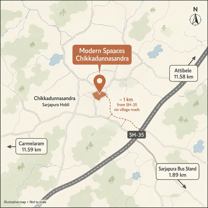
Why "Chikkadunnasandra, Sarjapura Hobli, Anekal Taluk" is the string that counts
Buyers searching for this project will type "Sarjapur Road". Sellers will say "Sarjapur". Neither is the administrative address, and the difference is not pedantry.
The taluk determines which revenue administration holds the land records for Sy. Nos. 18 and 19, and which sub-registrar's jurisdiction a sale deed for this parcel falls into. This site does not name a specific office, because we have not verified one — but a buyer doing due diligence should establish it early, since it governs where the encumbrance certificate is pulled from and where registration eventually happens. Anekal Taluk is a distinct revenue unit from the taluks that cover the inner Sarjapur Road stretch closer to the city.
The village name is the other load-bearing string. Chikkadunnasandra is the revenue village; a title search, a mutation record and a khata extract will all be indexed under it, not under "Sarjapur Road". The pincode 562125 and the hobli, Sarjapura Hobli, complete the address that a lawyer will actually work with.
The practical consequence for a buyer is simple. Any document that describes this project as being in a different village, a different taluk, or under a different planning authority is describing something other than what has been filed. The filed string is Chikkadunnasandra Village, Sarjapura Hobli, Anekal Taluk, Bengaluru Urban District.
The coordinate this page publishes, and exactly what it is
We publish 12.85203, 77.77402. That is an inferred figure, and here is the working.
The promoter submitted a KML site file with the application, named "modern spaace realty llp_project site.kml". That file carries a bounding box running from latitude 12.85072 to 12.85334 and from longitude 77.77317 to 77.77486. The extents are verified — they are what the promoter lodged. The coordinate we publish is the geometric centre of that box, which is our own derivation, and we hold it at medium-high confidence rather than treating it as a surveyed point.
The reason for the hedge is worth stating. The submitted bounding box covers roughly 5.33 hectares. The parcel inside it is 3.0755 hectares. Up to about 42 per cent of the box is therefore not the parcel at all. We say a point falls inside the submitted KML extent; we never say it falls inside the project boundary, because the extent is a rectangle drawn around a parcel, not the parcel itself. Anyone treating our published centre as a plot corner, a gate position or a boundary marker is over-reading it.
Two further notes on coordinates:
- A latitude and longitude pair circulating in the marketing material sits roughly 309 metres north of the centre of the filed extent, and falls outside that extent altogether. We do not reproduce it and we do not publish it. It is not where the filing puts the site.
- The Plus Code VQ2F+HJ5 does fall inside the filed KML extent, about 72 metres from its centre. That is consistent with the filing, and it is the more reliable of the two locators in circulation.
We publish no more than five decimal places on either figure, because the underlying derivation does not support more precision than that.
The site does not front Sarjapur Road
This is the correction that changes how the location reads.
The parcel does not have frontage on Sarjapur Road, and it does not front State Highway 35. The honest description is that the site sits about a kilometre off the Sarjapur Road (SH-35) alignment, reached by village roads. That "about a kilometre" is a separation measured across the map between the parcel and the highway alignment — it is not a travel distance, and this page does not present it as one.
The nearest stretch signed as Sarjapura Road, carrying the SH-35 reference, lies to the north of the parcel. The nearest alignment of SH-35 of any description lies to the east. The NH-648 alignment — the Dabaspete–Hosur road, part of the Satellite Town Ring Road scheme — lies further east again. We publish no distance to any of them, because the only measurements we hold for road alignments are map separations rather than routed distances, and this site does not publish map separations as distances.
What the parcel does connect to is a network of unnamed village roads. The nearest named road of any class is under a kilometre away across the map. Everything a resident does — the school run, the commute, the hospital trip — begins on that unnamed local network before it reaches anything with a highway number.
For a buyer, this produces three concrete questions to ask on site, none of which the filings answer:
- What is the width and surface condition of the access road serving Sy. Nos. 18 and 19 today?
- Who is responsible for maintaining and, if necessary, widening it — and is any widening actually sanctioned rather than merely drawn?
- What does that access road look like on a weekday morning, once 826 households are using it?
If material about this project places the site on the arterial itself, or credits it with highway frontage, that material is not describing what has been filed — and the rest of it deserves the same scrutiny.
Connectivity from Modern Spaaces Sarjapur Road, by road
Every figure in the tables below is a road distance in kilometres, computed on the OpenStreetMap driving network from the site pin at 12.85203, 77.77402. No straight-line figure appears in any of them. Where the road distance diverges sharply from what a map would suggest, the divergence is flagged, because that divergence is one of the more useful things this table shows.
Everyday needs within three kilometres by road
| Destination | By road |
|---|---|
| Sarjapura Urban Primary Health Centre | 1.80 km |
| Sardhar Vallabhbai Patel Education Society | 1.75 km |
| Sarjapura Bus Stand | 1.89 km |
| Ravi Theater | 1.98 km |
| Healing Hands Clinic, Sarjapura | 2.07 km |
| Spandana | 2.19 km |
| Sri Ram Public School | 2.37 km |
| Town Hospital | 2.59 km |
| APMC Market | 2.66 km |
| Sompura Lake | 2.75 km |
This is the strongest part of the location's case, and it is genuinely strong. Sarjapura town — its bus stand, its market, a primary health centre, a clinic, a private hospital and two schools — is inside three kilometres by road. A household that does not need to leave the immediate area on a given day will not have far to go.
Workplaces reachable from Chikkadunnasandra
| Destination | By road |
|---|---|
| SABIC India Technology Center | 4.26 km |
| Aruani Grid | 6.55 km |
| Stellar 23 | 7.70 km |
| Nambiar District 25 | 7.94 km |
| Wipro SEZ | 9.68 km |
| Prestige Tech Habitat | 10.95 km |
| RGA Tech Park | 11.39 km |
| Wipro Corporate Office | 13.53 km |
| TCS Think Campus | 13.79 km |
| Sattva South Avenue | 13.84 km |
| Salarpuria Sattva Alexandria Tech Park | 13.85 km |
| Tech Mahindra | 13.93 km |
| Bengaluru Lifesciences Research District | 14.02 km |
| D-Link India | 14.05 km |
| Infosys Foundation, Konappana Agrahara | 14.94 km |
| HCL Technologies | 15.48 km |
| Delta Electronics, Bommasandra | 16.66 km |
| Biocon, Hebbagodi | 18.26 km |
The shape of this table is the honest picture of the commute. There is one substantial employer inside five kilometres by road. Then there is a gap. The bulk of the campus-scale employment that people buy into this corridor for — the tech parks, the pharmaceutical and electronics manufacturing at Bommasandra and Hebbagodi — sits between about 13 and 18 kilometres away by road.
That is a real commute in Bengaluru conditions, and it is a commute that begins on a village road. Buyers who work at one of the 13-to-18 kilometre destinations should drive the route themselves, at the hour they would actually drive it, before committing.
Rail, metro and bus from Chikkadunnasandra
There is no operational metro or railway station within ten kilometres of this site. That is the plain finding and it should be stated before anything else.
| Transit point in the routed set | By road |
|---|---|
| Sarjapura Bus Stand | 1.89 km |
| Huskuru | 8.77 km |
| Attibele | 11.58 km |
| Carmelaram | 11.59 km |
| Heelalige | 13.33 km |
Carmelaram, at 11.59 km by road, is the nearest rail of any kind. Not the nearest convenient rail, not the nearest suburban halt — the nearest rail. Anyone who intends to use a train regularly should treat that eleven-and-a-half kilometres as part of the daily journey, not as a footnote to it.
For day-to-day public transport, the practical answer is the bus. Sarjapura Bus Stand is 1.89 km by road and is comfortably the most useful transit asset the site has.
On Namma Metro Phase 3A, see the section on proposed infrastructure below. This page publishes no distance to a Phase 3A station, for the straightforward reason that no station location has been published.
Schools and colleges by road
| School | By road |
|---|---|
| Sardhar Vallabhbai Patel Education Society | 1.75 km |
| Sri Ram Public School | 2.37 km |
| Aikhyatha Public School | 3.17 km |
| New Oxford | 3.94 km |
| Azim Premji School | 4.07 km |
| Oakridge International School | 5.24 km |
| Indus International School | 5.54 km |
| Head Start Educational Academy | 5.77 km |
| The International School Bangalore | 6.31 km |
| United World Academy | 6.37 km |
| Silver Oaks International School | 6.55 km |
| Inventure Academy | 6.80 km |
| Bethany High Sarjapur | 6.91 km |
| Global Indian International School | 7.26 km |
| Greenwood High | 7.38 km |
| Delhi Public School Bangalore East | 8.57 km |
| Deens Academy, Gunjur Campus | 9.20 km |
| Ebenezer International School Bangalore | 11.00 km |
| College or institute | By road |
|---|---|
| ALLEN Career Institute | 3.01 km |
| Azim Premji University | 3.93 km |
| International School of Management Excellence | 4.10 km |
| National School of Business | 10.33 km |
| Krupanidhi Institutions | 11.06 km |
| Xavier Institute of Management and Entrepreneurship | 13.96 km |
| PESU Electronic City Campus | 15.02 km |
The schooling depth in this band is the corridor's genuine strength: more than a dozen established international and private schools sit inside eight kilometres by road, and the routed table finds two options inside 2.4 km. Azim Premji University at 3.93 km by road is the closest higher-education anchor of any scale.
Healthcare by road
| Destination | By road |
|---|---|
| Sarjapura Urban Primary Health Centre | 1.80 km |
| Healing Hands Clinic, Sarjapura | 2.07 km |
| Spandana | 2.19 km |
| Town Hospital | 2.59 km |
| Sri Lakshmi Multi Speciality Hospital | 5.22 km |
| Government Hospital, Gunjur | 9.67 km |
| Snehadaan Hospital | 9.84 km |
| Sahasra Hospital | 11.17 km |
| Sparsh Hospital, Bengaluru Urban | 15.15 km |
| Mazumdar Shaw Medical Center | 15.21 km |
| Narayana Hrudayalaya | 15.35 km |
The pattern repeats: everyday and secondary care is close, tertiary care is not. A clinic, a primary health centre and two hospitals sit inside three kilometres by road. The large multi-speciality and quaternary institutions are around fifteen kilometres by road. For a household with a member who needs regular specialist care, that fifteen-kilometre leg is the number to plan around.
Retail, markets and open water
| Destination | By road |
|---|---|
| APMC Market | 2.66 km |
| Confident Square Mall | 4.12 km |
| CSK Mall | 10.43 km |
| Arcadia | 11.71 km |
| M5 ECity Mall | 14.51 km |
| Sompura Lake | 2.75 km |
| Hosahalli Lake | 3.53 km |
| Sarjapura Lake | 4.08 km |
| Yamare Lake | 4.38 km |
| Sarjapur Doddakere Lake | 4.77 km |
| Thiagalara Chowdenahalli Lake | 4.82 km |
Organised retail is thin. Confident Square Mall at 4.12 km by road is the nearest, and the next options are ten kilometres and beyond. Everyday provisioning is served by the APMC Market at 2.66 km and by Sarjapura town generally. The lake cluster within five kilometres by road is real open space, though as the next section shows, several of these are much further to drive than they look.
Where the map misleads: the detour ratios around Chikkadunnasandra
This is the most useful finding in the routed table, and it is one that no distance chart on a listing portal will show you.
A detour ratio is the road distance divided by the straight-line distance. A ratio near 1.2 is normal. A ratio above roughly 1.6 means the road network has diverged sharply from the map, and a ranking done on the map will be wrong.
| Destination | By road | Detour ratio |
|---|---|---|
| SABIC India Technology Center | 4.26 km | ×4.29 |
| Azim Premji University | 3.93 km | ×4.12 |
| Azim Premji School | 4.07 km | ×3.78 |
| Hosahalli Lake | 3.53 km | ×3.29 |
| Anganwadi | 3.35 km | ×2.68 |
| Indus International School | 5.54 km | ×2.61 |
| Sarjapura Lake | 4.08 km | ×2.33 |
| ALLEN Career Institute | 3.01 km | ×2.07 |
| Sarjapur Doddakere Lake | 4.77 km | ×2.06 |
Read that table carefully, because it inverts the usual assumption. The destinations closest to this site on a map are the worst served by road. Azim Premji University and SABIC's technology centre are both roughly a kilometre away as the crow flies, and both take about four kilometres of driving to reach — 3.93 km and 4.26 km respectively. There is no direct road link between the site and those points; the network routes around.
The same effect applies further out, on the highway legs.
| Destination | By road | Detour ratio |
|---|---|---|
| Biocon, Hebbagodi | 18.26 km | ×1.76 |
| Delta Electronics, Bommasandra | 16.66 km | ×1.67 |
| Heelalige | 13.33 km | ×1.65 |
| Nambiar District 25 | 7.94 km | ×1.64 |
| Huskur Road | 16.23 km | ×1.54 |
| Attibele | 11.58 km | ×1.40 |
The practical consequence is that any marketing map showing this project with radius rings drawn on it will overstate what is close. If you are assessing this location, use the road column and ignore the rings.
Why this page publishes no drive times
We hold both a free-flow travel-time floor and a peak-hour ceiling for every destination above, and we publish neither as a headline number.
The reason is that a single minute figure for a Bengaluru journey is nearly always wrong. The free-flow figure describes an empty road that does not exist at any hour a commuter travels. The peak figure is derived from a city-wide congestion rate, which is a fair ceiling for stop-start city streets but materially overstates a long highway leg where traffic actually moves.
Quoting a single minute figure for any of the legs above would therefore be a fabrication dressed as precision. Kilometres by road are a measured quantity and they do not change with the hour. That is what this page gives you. If you want a time, drive the route yourself on a weekday morning.
Proposed versus built: what is actually there today
This distinction is where most location writing about the Sarjapur corridor goes wrong. Three pieces of infrastructure are routinely attached to sites in this area. Here is the position on each.
Namma Metro Phase 3A
Sarjapur is the proposed southern terminus of Namma Metro Phase 3A. The line was approved by the Karnataka Cabinet on 6 December 2024. Cost figures have been reported in a range between Rs 25,485 crore and Rs 28,405 crore, varying by source and by detailed project report revision; we make no claim about which figure is current or in which direction it has moved. The line remains awaiting Union Cabinet approval.
Critically: no alignment and no station location has been published. This page therefore publishes no distance from the site to any Phase 3A station, and no travel time to one. Any material that gives you such a distance has invented it — there is no published station to measure to. With the alignment not in the public domain and Union Cabinet approval still outstanding, Phase 3A is not something a buyer can price into a decision made today.
The Sarjapur Road widening claim
A proposed widening of the Sarjapur Road corridor, quoted at a specific carriageway width, is frequently attached to projects in this area, including this one. We do not publish that width, because no such widening is corroborated for the Sarjapura–Attibele stretch.
The only corroborated widening on Sarjapur Road is on the inner stretch, from Iblur Junction to Carmelaram — a 4.7 kilometre section widened in 2022. That work begins roughly ten to fourteen kilometres away from this site, measured across the map rather than along a route. The work is real; it is simply not this stretch of road, and attaching it here would mislead a buyer about what is coming to the road outside the gate.
SWIFT City
SWIFT City is also routinely attached to sites in this area. The nearest village named in the acquisition set is Bikkanahalli, which is a different settlement from Bikkanahalli Hosahalli near this site — similar names, distinct places. We publish no distance to it, because the only measurement we hold is a map separation rather than a routed road distance, and we do not publish map separations as distances. Nor do we repeat the acreage figure that circulates alongside it, attributed to Hosahalli: it is unsourced, and it has been pinned to the wrong village.
If SWIFT City matters to your purchase decision, verify the acquisition notification and the village list yourself before treating it as a factor here.
Two Modern Spaaces filings in the same revenue village
A buyer researching this location will encounter two Modern Spaaces schemes in Chikkadunnasandra Village, and they are easily confused.
| Item | This project | The other filing |
|---|---|---|
| Promoter | Modern Spaace Realty LLP | Modern Spaace Developers LLP |
| Proposal number | SIA/KA/INFRA2/582779/2026 | SIA/KA/INFRA2/582342/2026 |
| State file | SEIAA 220 CON 2026 | SEIAA 217 CON 2026 |
| Survey numbers | 18 and 19 | 13, 90/1 and 91/1 |
| Land | 7.60 acres | 10.77 acres |
| Units | 826 | 1,002 |
| Floors | 2BF + GF + 45UF | 2BF + GF + 34UF |
Both were granted Standard Terms of Reference on the same day, 2 July 2026. They are separate projects on non-contiguous parcels — the two filed extents do not adjoin. We make no claim about who owns the land between them, because no land record was consulted. We also do not describe them as phases of a single masterplan; nothing in either filing supports that reading.
For location purposes the relevant point is simply this: the same developer has two separate high-rise schemes filed in one revenue village, granted Terms of Reference on the same day, in an area served by village roads. One records 826 units, the other 1,002. That is a material fact about how this locality is likely to change, whatever the relationship between the two filings turns out to be.
Modern Spaaces in Chikkadunnasandra before this project
The developer is not new to this village. 77 East is registered with the Karnataka Real Estate Regulatory Authority at Sy 7/4, Cozy Home Layout, Chikkadunnasandra Village, under registration number PRM/KA/RERA/1251/308/PR/200103/003119. That number belongs to 77 East, not to this project.
Modern Spaaces is a Sarjapur-corridor specialist, and it has already registered and built in this exact revenue village. That is a genuine point in the location's favour. A developer holding an existing registration in the same revenue village has already dealt with this village's access, its approvals and its local administration once before, which a first-time entrant to Chikkadunnasandra has not.
Where this project stands with RERA
Modern Spaaces Sarjapur Road is not registered with the Karnataka Real Estate Regulatory Authority, and no application is pending. Under Section 3 of the Real Estate (Regulation and Development) Act 2016, a project falling in a registrable class cannot lawfully be advertised, marketed, booked or sold until registration has been granted. No RERA number exists for this scheme, and any number you are shown for it is either another project's or invented.
The environmental position is separate and equally worth understanding. Standard Terms of Reference were granted on 2 July 2026; the environmental clearance application was filed on 18 August 2026 and remains under verification. A Terms of Reference is permission to conduct the environmental impact assessment study — it is not a clearance. Nothing about this project has been environmentally cleared. The proposal sits in Category B1 under Schedule 8(b), Townships and Area Development Projects, with a filed project cost of Rs 415.11 crore.
This microsite is an information and enquiry resource for a scheme at the approvals stage. It is not a booking channel, and no booking, allotment or payment should be made against this project by anyone until registration is granted.
The honest trade-offs of this location
Nothing above is meant to talk you into or out of this site. Here is the balance, stated as directly as we can.
What genuinely works. Sarjapura town is inside three kilometres by road, with a bus stand at 1.89 km, a primary health centre at 1.80 km, two hospitals inside 2.6 km and a market at 2.66 km. The schooling depth is real — more than a dozen established schools inside eight kilometres by road, and Azim Premji University at 3.93 km. There is a substantial employer, SABIC's technology centre, at 4.26 km. Half a dozen lakes sit within five kilometres by road. The developer has prior registered work in this same village.
What does not. The site does not front an arterial road. It is about a kilometre off the SH-35 alignment and it is reached by unnamed village roads, which means the quality of the last mile is a question the filings do not answer and a site visit must. There is no operational rail or metro station within ten kilometres; Carmelaram at 11.59 km by road is the nearest rail of any kind. The campus-scale employment that drives demand in this corridor is 13 to 18 kilometres away by road. Organised retail beyond one mall at 4.12 km is thin. And the detour ratios show that the immediate surroundings are worse connected by road than any map suggests, with the two nearest institutions of any scale taking four times their map distance to reach.
What is not yet real. Metro Phase 3A is approved by the state cabinet and awaiting the Union Cabinet, with no published alignment and no published station. The Sarjapur Road widening that gets attached to this area belongs to a different stretch of it, ten to fourteen kilometres away across the map. SWIFT City's nearest named acquisition village is a different settlement from the similarly-named one near this site. None of these three should carry weight in a purchase decision made today.
What the project itself has not yet cleared. No RERA registration. No environmental clearance — only a Terms of Reference to begin the study. No published marketing name, no published floor plans, no published price, and no declared possession date. An 826-unit scheme rising to 45 upper floors, in a village served by village roads, raises exactly the questions that the pending environmental impact assessment exists to examine — and that assessment is not finished.
If you are considering this location, the sequence we would suggest is: drive the access road at peak hour, confirm the survey numbers and the taluk with your own lawyer, and wait for the RERA registration before any money changes hands.
Modern Spaaces Sarjapur Road Location — frequently asked questions
Is the project on Sarjapur Road?
No, and this is a correction worth making plainly. The site sits about a kilometre off the Sarjapur Road (SH-35) alignment and is reached by village roads. The stretch carrying the SH-35 reference lies to the east of the parcel and the length actually named Sarjapura Road lies to the north; the nearest named road of any class is B Hosahalli Road. Local access to the parcel is by unnamed village roads, and the scheme has no direct arterial frontage. That is not necessarily a drawback — a quieter approach is often the point of a site like this — but it is not what "on Sarjapur Road" implies. Anyone describing this project as fronting SH-35 is describing something other than the land in the filing.
What schools are near the site?
The closest options by road are Sardhar Vallabhbai Patel Education Society at 1.75 km and Sri Ram Public School at 2.37 km, followed by Aikhyatha Public School at 3.17 km and New Oxford at 3.94 km. The larger international schools that the Sarjapur corridor is known for sit further out: Oakridge International School 5.24 km, Indus International School 5.54 km, The International School Bangalore 6.31 km, Inventure Academy 6.80 km and Greenwood High 7.38 km, all by road. Azim Premji School is 4.07 km by road despite being barely a kilometre away on the map — another case where the road network more than triples the map distance. Check admissions and bus routes directly with the schools.
What healthcare is near the site?
For routine care, Sarjapura Urban Primary Health Centre is 1.80 km by road, Healing Hands Clinic is 2.07 km, Spandana is 2.19 km and Town Hospital is 2.59 km. Sri Lakshmi Multi Speciality Hospital is 5.22 km by road. Beyond that the picture thins considerably: the larger multi-speciality names most Bengaluru buyers would recognise sit past the eleven-kilometre mark, with Narayana Hrudayalaya, Mazumdar Shaw Medical Center and Sparsh Hospital all in the 15 km range by road. So day-to-day and urgent primary care is close at hand, while anything requiring a large tertiary hospital means a long drive through corridor traffic. That is a real consideration for older family members.
What about markets, shopping and everyday errands?
Sarjapura town supplies the basics and it is close. APMC Market is 2.66 km by road, Ravi Theater 1.98 km, and Confident Square Mall 4.12 km. Azim Premji University is 3.93 km by road and ALLEN Career Institute 3.01 km, which gives the immediate area a student population and the small commerce that follows one. Sompura Lake is 2.75 km by road. Organised retail on the scale of a large mall means travelling — CSK Mall is 10.43 km and M5 ECity Mall 14.51 km by road. For a household used to the inner city, expect Sarjapura town for daily needs and a planned trip for anything else.
Which company is the legal promoter named on the filings?
The promoter recorded on the environmental filing is Modern Spaace Realty LLP — note that the legal entity name carries no trailing "s", even though the brand does. This matters more than it sounds. Modern Spaaces builds through a fleet of single-project entities rather than one holding company, so the name on your agreement will very likely be this LLP and not the brand you have been reading about. The same registered office at No. 73/2, Chambenahalli Village ties the LLP to the group. When you check documents, check them against the LLP name exactly as it appears on the certificate, and expect the brand name to appear only in marketing material.
Enquire about Modern Spaaces Sarjapur Road
Modern Spaaces Sarjapur Road is at the stage where the useful thing is information rather than a booking, because there is no lawful booking to make. Leave your details and we will tell you when the position changes — when a Karnataka RERA number is issued, when the environmental file moves, and when the developer publishes a price, a floor plate and an amenity schedule. The enquiry form asks for a name, phone number, email address and message; name and phone are required.